
Bristol ZIP Codes and Their Postal Roles
Bristol is a town and city with coextensive boundaries, but postal service uses delivery areas and mailing routes rather than the legal town line. In Connecticut, Bristol is in Hartford County, a geographic designation rather than an operating county records office. The Connecticut Secretary of the State post-office list gives the clearest verified local starting point: it lists Bristol 06010 and the Forestville Branch in Bristol with 06010. The same research found 06011 in Bristol municipal mailing evidence, while its current service classification was not confirmed from a live USPS result. That difference matters. A postal listing can support a ZIP label, but it cannot by itself prove that every nearby parcel, voter record, or community label uses the same geography.
| ZIP Code | Areas Covered | Post Office | Notes |
|---|---|---|---|
| 06010 | Bristol street delivery; Forestville postal context | Bristol and Forestville Branch | Strongest verified Bristol street-delivery listing; confirm each address with USPS. |
| 06011 | Bristol municipal mailing evidence, including a PO Box route | Bristol mailing context | Current service type was not confirmed; do not label it street delivery or PO-box-only without USPS. |
| 06062 | No Bristol street address confirmed in the research | Plainville area reference | Nearby ZIP question only; do not publish it as Bristol coverage without an exact USPS result. |
The table separates a verified postal entry from two careful qualifications. The official list supports 06010 for Bristol and Forestville Branch. Bristol municipal correspondence uses 06011-1040 for a PO Box, and USPS bulletin material places 06011 in Bristol postal contexts, yet the research did not expose a current service-type label. A 06062 discussion belongs to nearby Plainville, not to a Bristol coverage claim. That is why each Bristol address should be checked on its own before a ZIP code is used to sort records.
The image below is a source capture from the Connecticut post-office list, the official source behind the Bristol and Forestville entries above.
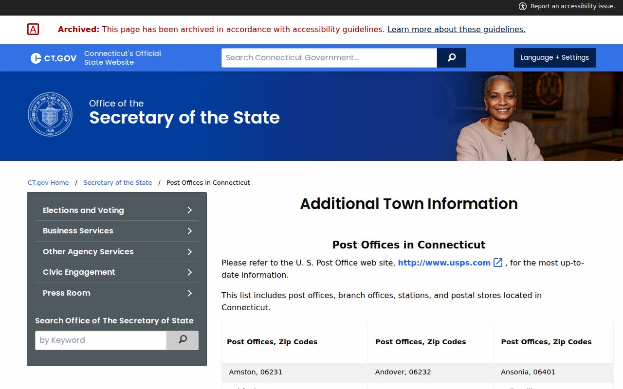
This capture preserves the postal-list context, not a current boundary map. Use the exact-address USPS route for a delivery decision.
Bristol 06010: Street Delivery and Forestville
06010 is the best-supported street-delivery entry for Bristol. The state post-office list also names the Forestville Branch with that code, so the postal label can appear beside a Forestville place name while the legal municipality remains Bristol. Forestville is also a local geography in the city-linked neighborhood material and in election-district descriptions. Those uses overlap in daily speech, but they are not interchangeable records fields. A directory entry may say Forestville, a parcel may say Bristol, and the mail route may still use 06010.
For a current address, the ZIP code is a delivery clue rather than a substitute for a parcel search. Enter the house number and street in the USPS ZIP Code Lookup, save the returned label and date, then compare it with Bristol GIS or Vision. If the question is about a nearby resident or parcel, keep the USPS answer beside the local record instead of changing the local record to match a postal phrase. A Forestville label does not create a separate town record, and a 06010 result does not identify everyone connected to an address.
Note: Forestville can be a village, neighborhood, directory locality, or branch-post-office label while the legal municipality remains Bristol.
Bristol 06011 and the PO Box Address
06011 needs a different kind of reading. Bristol municipal mailing evidence uses PO Box 1040 with a Bristol 06011-1040 address. USPS Postal Bulletin material also places 06011 in Bristol postal contexts. The available evidence supports a mailing and PO Box trail, but it does not establish a current street-delivery boundary or a permanent PO-box-only classification. The live city and state result needed to settle that service question was not retrievable during research.
That limitation changes the workflow. A 06011 mailing address can identify where correspondence is routed without identifying the parcel where a person, office, or organization is physically located. Use the postal lookup for the current service result, then use the Bristol GIS parcel record or Vision property search for a situs, account, or owner field. If a deed, voter record, or court result uses a different address role, preserve both values and name the source that supplied each one.
Do not treat 06011 as a unique ZIP for one institution, and do not infer that a Bristol street carries 06011 simply because a municipal PO Box does. The directory keeps the evidence qualified until USPS confirms the exact address or route.
Finding Bristol Residents by ZIP Code
A Bristol ZIP code directory search works best as a four-part handoff. USPS answers the postal question first. Bristol's property systems then connect an address to a parcel or mailing field. The voter route has its own privacy and public-display limits. None of those sources is a complete list of every person at a ZIP address, so a name result should keep its source and date.
- Check the exact house number and street in the USPS lookup. Save the returned ZIP and postal city, and use the city/state route only as a broad check because the research did not capture its full live output.
- Open the Bristol GIS property search with House No and Street, or with Owner/Co-owner or Account when those keys are known. Read MAIL_ZIP from the parcel result, and keep it separate from LOCATION, STREET, and HOUSE_NO.
- Use the Vision Bristol property search with Address, Owner, Acct#, Mblu, PID, or All. The form did not show a ZIP filter, so search by an address or another parcel identifier and inspect the returned location and mailing fields.
- For registration questions, use the Connecticut voter lookup or contact the Bristol registrars. Public ZIP-wide or block-wide output was not verified, and privacy programs can suppress or substitute an address.
Once a ZIP narrows the search to a street, move to the Bristol street directory for the address-keyed record chain. That next step belongs to the parcel, deed, and street fields, not to an assumption that one postal code contains one kind of household.
Note: A USPS city and state result is a delivery clue, not proof that every address in a named Bristol area shares one ZIP.
Bristol GIS Fields Behind ZIP Searches
The local property systems do not expose the same ZIP control. USPS is the address-level source for delivery assignment. MapXpress searches by parcel-related keys and returns mailing data. Vision searches by several property identifiers, then displays the fields available in its assessment record. Reading the fields in their proper role prevents a mailing ZIP from being mistaken for a parcel situs.
| Portal | Field or Route | Type | Required | Observed Bristol Behavior |
|---|---|---|---|---|
| USPS ZIP Lookup | Street address | Text route | Depends on selected route; live behavior not inspected | Address-level ZIP search; exact result output was not captured. |
| USPS ZIP Lookup | City and state | Text/select route | Depends on selected route | Broad postal check; do not use it as a parcel boundary map. |
| MapXpress | House No and Street | Text plus select | No visible marker | Street list includes All Streets and a long live Bristol list; full list was not reproduced. |
| MapXpress | Owner/Co-owner or Account | Text | No visible marker | Alternative parcel keys; the result can expose MAIL_ZIP and other parcel fields. |
| Vision | Search mode and criterion | Select plus text | No visible marker | Address, Owner, Acct#, Mblu, PID, or All; no visible ZIP mode. |
MapXpress reports approximately 21,972 parcels, parcel maps updated in February 2026, and property information updated nightly. Those are currentness notes, not a promise that every map layer or every mailing field changed on the same day. A parcel result may include an owner, account, MBL, location, mailing address, zoning, land use, coordinates, and edit or source fields. Use the ZIP field as one value in that record, then cite the capture date.
Forestville in Bristol's Postal Geography
Forestville shows why a ZIP code directory needs more than one label column. The city-linked neighborhood page names Forestville among Bristol community areas. The State Election Enforcement Commission district guide uses Bristol, Edgewood, and Forestville as community names in election descriptions. Bristol's Plan of Conservation and Development summary describes Forestville as an industrial village along the Pequabuck River, with a late-nineteenth-century train station and later effects from the 1955 flood and Route 72 traffic.
The same place can therefore carry several valid descriptions, each owned by a different system:
- Legal municipality: Bristol, the town and city with coextensive boundaries.
- Postal city and ZIP: the delivery assignment supplied by USPS, such as Bristol 06010.
- Village or neighborhood: Forestville, Federal Hill, Downtown, or another local label used for community context.
- Parcel situs: the LOCATION, STREET, HOUSE_NO, and MUNI fields attached to a Bristol parcel.
- Mailing destination: MAIL_ADDR, MAIL_CITY, MAIL_STATE, and MAIL_ZIP, which can point to a PO Box or another destination.
That is why the Bristol directory keeps postal, parcel, and community terms side by side. A matching word is useful only after the source role is clear.
Bristol ZIP Code Boundaries vs City Limits
A ZIP Code does not function as a legal town boundary. The research located no official current ZIP-boundary shapefile or Bristol-specific ZIP realignment timeline. It also did not verify a Bristol street address using 06062, even though Plainville appears in nearby postal discussions. The safe approach is to check the exact address, then compare the USPS result with the parcel municipality, election custodian, and court or probate geography.
When values conflict, do not smooth them into one label. Preserve the postal city, ZIP, parcel situs, mailing destination, neighborhood name, and date checked. This is especially important at Forestville, around civic PO Boxes, near municipal edges, and wherever an older directory or deed uses a different locality name.
- ZIP versus ZIP+4
- The five-digit ZIP identifies a broad delivery area. The extra four digits narrow the route or delivery segment; they do not create a legal parcel boundary.
- PO-box ZIP
- A postal code used to route mail to boxes or a special mailing group. It may not reveal a physical situs, and Bristol's 06011 service type needs current USPS confirmation.
- Unique ZIP
- A code assigned to one institution or special address group. No Bristol unique-ZIP assignment was verified in the research.
- Carrier route
- A delivery path within a ZIP area. It helps postal operations and is not a town, neighborhood, or parcel boundary.
Exact-address check. USPS controls current delivery assignment. A Bristol ZIP can sort a search, but it does not replace parcel, deed, voter, or court geography.
A Currentness Check for Bristol ZIP Data
Postal instructions can become stale even when a ZIP number looks familiar. The Bristol GIS page reports a February 2026 parcel-map update and nightly property updates. The Town Clerk's land-record gateway changed to Cott RecordHub on May 4, 2026, but that change does not turn RecordHub into a ZIP service. The state post-office list supports 06010 and the Forestville Branch, while current USPS address output remains the final check for delivery.
Before using a Bristol ZIP code directory result, record the link, the date checked, and the exact address or field searched. Recheck 06011 rather than repeating the PO Box evidence as a street-delivery claim. Leave 06062 unconfirmed unless USPS returns a Bristol address. If a local record shows a different mailing or community label, keep both values and explain their roles.
The result is more useful when it shows uncertainty plainly. Bristol has a documented postal starting point, detailed parcel fields, and named community geography, but no single public ZIP boundary file that resolves every edge case. A dated source trail lets a later researcher verify a changed route without mistaking a stale page for a current address.
Note: Verify postal service, portal fields, office hours, and fees with the named custodian before submitting a request.